
Kugelmugel
Republic of Kugelmugel Republik Kugelmugel (German) Micronation | |
|---|---|
 Flag
 Official seal
| |
| Status | Nominally independent[citation needed] micronation subject to Viennese authority |
| Location | 2., Antifaschismusplatz 1, Prater, Vienna, Austria |
| Capital | Kugelmugel |
| Official languages | German |
| Demonym(s) | Kugelmuglian |
| Organizational structure | Republic |
• Leader | Mag. Linda Treiber |
| Establishment | |
• Declared | 19 December 1976 |
• Area | 94 square metres (1,010 sq ft) |
| Purported currency | Euro |
| Time zone | UTC+1 (CET) |
• Summer (DST) | UTC+2 (CEST) |
Kugelmugel, officially the Republic of Kugelmugel (German: Republik Kugelmugel), is a micronation located in Vienna, Austria. It came about as the result of a dispute between Austrian artist Edwin Lipburger and Viennese authorities, whose permission was required for him to build a spherical house.
The 'Republic' is currently administered by Linda Treiber.
History[edit]
In June 1982, the house was installed at the Prater park, near the Hauptallee, and surrounded by eight-foot-tall barbed-wire fences. The house occupies the only address within the proclaimed Republic, that being "2., Antifaschismusplatz" ("2nd district of Vienna; Anti-Fascism Square"), which has since been officially adopted by the city of Vienna[citation needed]. Lipburger died in January 2015, but the Republic retains an official population of more than 650 non-resident citizens. Closed sometime during the COVID-19 pandemic, it was reopened to visitors on the 1st of June 2024.
In German, the word "Kugel" means "ball" or "sphere"; "Mugel" is an Austrian German expression for a bump or a hill on a field, from which mogul skiing is also derived.
-
 The Republic of Kugelmugel
 -
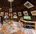 The interior of the spherical house


References[edit]
- Ryan, John; Dunford, George; Sellars, Simon (2006). Micronations: The Lonely Planet Guide to Home-Made Nations. Footscray, Victoria, Australia: Lonely Planet. pp. 82–85. ISBN 1-74104-730-7.
External links[edit]
 Media related to Kugelmugel at Wikimedia Commons
- Official website at the Wayback Machine (archived March 27, 2022) (in German)
48°12′56″N 16°23′46″E / 48.2155°N 16.3961°E
This Austrian location article is a stub. You can help Wikipedia by expanding it. |