
Talk:St. Johns River
 | St. Johns River is a featured article; it (or a previous version of it) has been identified as one of the best articles produced by the Wikipedia community. Even so, if you can update or improve it, please do so. | |||||||||||||||||||||
| This article appeared on Wikipedia's Main Page as Today's featured article on November 8, 2015. | ||||||||||||||||||||||
| ||||||||||||||||||||||
| This article is rated FA-class on Wikipedia's content assessment scale. It is of interest to the following WikiProjects: | ||||||||||||||||||||||||||||
| ||||||||||||||||||||||||||||


Move to St. Johns River?[edit]
Both this article and the vast majority of the official Florida state web docs [1] spell it "St. Johns River" -- "St." is not spelled out "Saint", and there is no possessive apostrophe. Can anyone who lives there verify? Catherine 01:46, 5 Mar 2004 (UTC)
- Very much agree with you. Change has been made. Official name is without apostrophe, and abbreviation St. is used by convention and is the standard Wikipedia usage too. -- Decumanus 22:25, 15 Mar 2004 (UTC)
- For what it is worth, the USGS names the river "Saint Johns River" (see http://geonames.usgs.gov/pls/gnispublic/f?p=162:3:2107129359454427199::NO::P3_FID:308105). A GNIS search for St. or St Johns River in Florida turns up no hits. Also, the USGS United States Board on Geographic Names "discourages" the use of periods, like St. Johns. Far be it from the feds to tell people how to spell placenames, I'm just pointing out the name as given on this page won't be found in a GNIS search. Perhaps a comment on the full spelling being "official" according to the USGS? Pfly 19:46, 7 January 2007 (UTC)
Only two major rivers flow north[edit]
Before it said only two rivers (period) flow north -- a very false statement.
http://www.ju.edu/tour/default.asp?page=17 mentions 'only two major'
http://www.geocities.com/loisnotlane/rivers.html -- look, a rivers that flow north website. Everything has a fandom.
Now myth is smashed with a reference but awkward wording. by jean-paul reid
DanielHolth 05:44, 26 December 2005 (UTC)
- I've noticed lots of river pages with claims about north flowing rivers being rare, but this is the first one I've seen with a claim of being the longest north-flowing river in the US. I have to wonder where one finds such information, and how truly north-flowing a river must be to count (no river flows absolutely directly north). Anyway, I began to compile a list of north-flowing rivers around the world to offer when I see claims of there being few such rivers. There are lots. And as for "longest north flowing river in the US" -- that URL mentioned above says there are only three, but I have found over 100 with pages on wikipedia in just an hour or two. St. Johns River is 310 miles long? The New River (West Virginia) is 320 miles long; the San Joaquin River is 330 miles; the Red River of the North is 545 miles (partially in Canada); the Powder River (Montana) is 375 miles; the Little Missouri River (North Dakota) is 560 miles; the Bighorn River is 461 miles; and there are others.. I've only compiled a partial list.
- So I suggest changing the text to be "one of the longest north flowing rivers in the US", or providing a more rigorous definition. I'll make the change myself in a few days if no one complains. It's all part of my Campaign to Address Questionable Superlatives on Wikipedia. :-) Pfly 06:26, 27 October 2006 (UTC)
- Its been just about two years and the issue has not been resolved, i am changing it to pfly's suggestion. —Preceding unsigned comment added by 97.104.32.27 (talk) 20:08, 23 August 2008 (UTC)
Bridges in Jacksonville[edit]
Are the bridges that cross the river truly relevant to the article? If so, shouldn't all major bridges that cross the river be mentioned? Spahi 00:36, 5 August 2006 (UTC)
[edit]
The article claims that the St Johns River is the third longest navitable north-flowing river in the world - after the Nile and the Amazon. Is 'navitable' a word? If 'navigable' is meant then is this so? The Amazon does not flow north. I suspect that Europe and Asia is full of north flowing rivers which would exceed the St Johns in terms of navigable length (the Lena, the Rhine, the Yensei for example).
Stubebart (talk) 08:54, 22 September 2008 (UTC)
- I took it out, there are a dozen or so that are longer in Russia alone. Kmusser (talk) 15:45, 22 September 2008 (UTC)
Saint John's River named after John the Baptist?[edit]
As a native Floridian, I have been taught that the river was named after John the Baptist, but I see no wikipedia reference to this, either in this article or in the article section about places named after John the Baptist.
Was I misinformed? —Preceding unsigned comment added by 199.44.77.8 (talk) 13:34, 24 February 2009 (UTC)
Article rewrite[edit]
So I rewrote the article, not sure if I will nominate it for FA, but I would like to get it a GA designation at least.
I am in contact with the St. Johns River Water Management District to get permissions to use some of their basin maps. I will also try to add a couple more pictures of the Lake George and Ocklawaha River.
I'll be listing this at WP:Peer review, but if anyone has any suggestions, please feel free to make them to improve the article. --Moni3 (talk) 16:20, 20 July 2009 (UTC)
- I don't think the claim that the St. Johns River is one of the few North American rivers that flow north is accurate. For rivers in the US excluding Alaska, it seems accurate as you have rivers flowing west from the Rockies, east from the Appalachians, and south between the mountain systems, dominated by the Mississippi-Missouri system. In Canada, this isn't the case. While the rule in the west applies, in the east and in the centre, as a whole it doesn't. The East is dominated by the St. Lawrence River system; while the upper lakes go weast-east, the system definitely turns north. In the centre, many rivers flow east towards the Hudson Bay, but as you get closer to the Arctic Ocean, great rivers like the Yukon (located mostly in Alaska) and Mackenzie rivers flow north. Some rivers flow north to the Hudson Bay, too, such as the Red River of the North (partially in the US) and the Nelson River. Maxim(talk) 16:24, 31 August 2009 (UTC)
- It is often cited to be so. I agree that it is not as unique perhaps as what has commonly been presented, but some very good sources have printed it. Thoughts? --Moni3 (talk) 16:38, 31 August 2009 (UTC)
- The idea that north flowing rivers are rare is a particularly persistent myth, you will find it printed in plenty of cases, but I wouldn't encourage it. Kmusser (talk) 16:49, 31 August 2009 (UTC)
- (ec) Those are obviously wrong, then. In the contiguous US, this may be true, but in Canada, the two biggest rivers flow north. The sources seem to be somewhat US-centric to me. ;-) Maxim(talk) 16:53, 31 August 2009 (UTC)
- From the source: Most rivers and streams in the Northern Hemisphere tend to flow toward the equator; that is, level, homogeneous, structureless, massive sediments would not bias or force drainage away from that trend. The Earth's centrifugal force seems to account for this, and, indeed, north-flowing rivers are rare north of the equator, the most famous being the Nile in North Africa. (Randazzo and Jones, p. 12) I don't see what's obviously wrong. --Moni3 (talk) 16:58, 31 August 2009 (UTC)
- That's weird... I believe that most important rule with bodies of water is that water flows down, so I doubt that it is rare. Outside the Nile and the bigger Canadian rivers, the Ob, Irtysh, Lena, Yenisei, (ie a very portion of Siberia -- the first Russian river that goes east that comes to my mind is the Amur, and that is relatively to the south, as it marks the border with China), and Amu and Syr Darya, all go north. Maxim(talk) 17:07, 31 August 2009 (UTC)
- Yes, they're wrong, I don't have a source saying they're wrong, but I can pull out an atlas and look at it and see that the idea that most North American rivers flow toward the equator is hogwash. Kmusser (talk) 17:20, 31 August 2009 (UTC)
- If you have a source that refutes this one, then we should discuss how to incorporate information from both or multiple sources. An atlas perhaps will not answer the issues written by Randazzo and Jones, unless you scrutinize all north-flowing rivers to ascertain the surrounding topography to account for why they flow north, which would also need sources. Furthermore, Randazzo and Jones are saying rivers in the entire Northern Hemisphere tend to flow towards the equator, not just in North America. --Moni3 (talk) 17:25, 31 August 2009 (UTC)
- Temporarily leaving aside whether Randazzo and Jones are right or not, the claim in the article has been proven to be inaccurate as there many major river systems that flow north. This means that rivers joining the main river must flow north, too, and that means there are countless minor streams and rivulets that will flow north, too. For example, Lake Champlain drains into the St. Lawrence River, which means it goes north via the Richelieu River. In the case of Randazzo and Jones, they are making false assumptions by neglecting that water wants to go down, so the elevation -- and as a result, plate tectonics -- plays a larger role. If a mountain range goes east-west, the water flowing down on the north side must go somewhere, and if the gradient is bigger when going north, the water will choose the path of least resistance to go down, which is north. Maxim(talk) 17:50, 31 August 2009 (UTC)
- There are two instances this language appears in the article. The first is in the lead. Per a brief mention here North America can be changed to United States, which I don't mind doing. The other instance is in the 2nd paragraph of the Formation and hydrology section, cited to the above Randazzo and Jones. Common (yet inaccurate) knowledge when I was growing up was that the St. Johns was one of 3 rivers in the northern hemisphere that flowed north. I don't think Randazzo are neglecting topography. In fact, that's what they say: unless something stands in its way or redirects it, a river in the Northern Hemisphere will flow south. Because the source makes it quite clear, I will not change it until another source is provided that refutes it. I will look at some other books in my library over the next few days, but if you know a source that can be used, please provide it. --Moni3 (talk) 18:17, 31 August 2009 (UTC)
- The part - In fact, that's what they say: unless something stands in its way or redirects it, a river in the Northern Hemisphere will flow south. - might very well be true, but there is always the local topography in the way, I don't see where their assertion would have any real world application, or even any way to test it. What I'm saying is if you actually look at the number of rivers that flow north it becomes obvious that they aren't all that uncommon, unfortunately that's OR, so I can't exactly cite it. If you look at Europe or northern Asia the idea is even sillier as most of the major rivers flow north.Kmusser (talk) 18:43, 31 August 2009 (UTC)
- Temporarily leaving aside whether Randazzo and Jones are right or not, the claim in the article has been proven to be inaccurate as there many major river systems that flow north. This means that rivers joining the main river must flow north, too, and that means there are countless minor streams and rivulets that will flow north, too. For example, Lake Champlain drains into the St. Lawrence River, which means it goes north via the Richelieu River. In the case of Randazzo and Jones, they are making false assumptions by neglecting that water wants to go down, so the elevation -- and as a result, plate tectonics -- plays a larger role. If a mountain range goes east-west, the water flowing down on the north side must go somewhere, and if the gradient is bigger when going north, the water will choose the path of least resistance to go down, which is north. Maxim(talk) 17:50, 31 August 2009 (UTC)
- If you have a source that refutes this one, then we should discuss how to incorporate information from both or multiple sources. An atlas perhaps will not answer the issues written by Randazzo and Jones, unless you scrutinize all north-flowing rivers to ascertain the surrounding topography to account for why they flow north, which would also need sources. Furthermore, Randazzo and Jones are saying rivers in the entire Northern Hemisphere tend to flow towards the equator, not just in North America. --Moni3 (talk) 17:25, 31 August 2009 (UTC)
- From the source: Most rivers and streams in the Northern Hemisphere tend to flow toward the equator; that is, level, homogeneous, structureless, massive sediments would not bias or force drainage away from that trend. The Earth's centrifugal force seems to account for this, and, indeed, north-flowing rivers are rare north of the equator, the most famous being the Nile in North Africa. (Randazzo and Jones, p. 12) I don't see what's obviously wrong. --Moni3 (talk) 16:58, 31 August 2009 (UTC)
- It is often cited to be so. I agree that it is not as unique perhaps as what has commonly been presented, but some very good sources have printed it. Thoughts? --Moni3 (talk) 16:38, 31 August 2009 (UTC)
<reset>I understand. I hope you do too that I'm going to stick with the only source I have, which is a pretty good one. To change it to what you like without sources would be original research. --Moni3 (talk) 18:46, 31 August 2009 (UTC)
- I suppose, I hate to leave things in that are demonstrably false with about 5 minutes of research. I went ahead and looked, grabbing the 100 longest rivers, deleting those in the southern hemisphere, I get 8 flowing west, 13 flowing east, 20 flowing south, and 20 flowing north. I know, Wikipedia is about verifiability, not truth. Kmusser (talk) 19:26, 31 August 2009 (UTC)
- Give me a couple days to run this down. I have a very good library at my disposal and I'll see what other sources have to say. --Moni3 (talk) 19:37, 31 August 2009 (UTC)
- The only part that gets me is the line "The majority of rivers in the Northern Hemisphere tend to flow south" which isn't right, and I'm not sure is really relevant to this article anyway. Kmusser (talk) 19:46, 31 August 2009 (UTC)
- Benke, Arthur C., ed., and Cushing, Colbert E., ed.; Carter, James L.; Resh, Vincent H. (2005). Rivers of North America. Burlington, Massachusetts: Elsevier Academic Press. ISBN 0-12-088253-1 is a useful source for river information. The introduction to Chapter 18, "Mackenzie River Basin", mentions that the Mackenzie basin covers "an area larger than central Europe" and that the river "is the largest northerly flowing river in North America". It goes on to say that "the system includes a number of major rivers, including, from north to south, the Athabasca, Peace, Slave, Liard, Arctic Red, and Peel rivers, as well as the main-stem channel of the Mackenzie River." These quotes come from page 805. The book is 1144 pages long and might have other data that would be relevant here. It has a section, pp. 99–104, devoted to the St. Johns River. Finetooth (talk) 20:49, 31 August 2009 (UTC)
- The only part that gets me is the line "The majority of rivers in the Northern Hemisphere tend to flow south" which isn't right, and I'm not sure is really relevant to this article anyway. Kmusser (talk) 19:46, 31 August 2009 (UTC)
- Give me a couple days to run this down. I have a very good library at my disposal and I'll see what other sources have to say. --Moni3 (talk) 19:37, 31 August 2009 (UTC)
I've noticed that this river is one of the most well-known and cited for being north-flowing and that such a thing is unusual for a river. I see I was arguing against it on this talk page four years ago! It seems so easy to disprove just by looking at an atlas. Further, the phrase "north flowing" is never defined in any of the sources I've seen which make the claim, making it impossible to even figure out which other rivers might be among the "few" others. The St. John River doesn't even flow due north, but a bit west of north. And that only if you smooth out all the meanders and the east-flowing mouth. Anyway, my point is that it is this river in particular that seems most often cited as only of the few north-flowing rivers in (the world/continent/USA/entirely within a state/whatever). There are plenty of (otherwise) reliable sources that say so, even though a few minutes of thought and some commonsense should make it clear that the claim is not only false--or at best poorly defined. A reliable source that contradicts the claim would be useful, but it seems to be a topic few geographers care to write about. Plus, the mythical rarity of north-flowing rivers seems particularly strong in America, even among otherwise reasonable people. And it is this river, the St. John, that seems to lead the pack on being widely cited in this way. I realize Wikipedia is about verifiability over truth and all, but what strikes me as notable here is not that the St. John River is one of the few north-flowing rivers of the US/continent/whatever,[1][2][3][4][5][6] but that the the river is so frequently said to be one of the few north-flowing rivers.[1][2][3][4][5][6] Perhaps some better way of phrasing the claim can be found, balancing WP:RS and WP:V with WP:COMMON? Maybe a few comments about how the claims are false and/or too poorly defined could be stated in a footnote, or would that run afoul of WP:OR? How does one balance WP:OR and WP:COMMON anyway? It seems to me that spending a few minutes looking at an atlas is hardly "research". For me I just have to think about local rivers--having grown up near the Niagara River and live now near the Duwamish River, Willamette River, Deschutes River, etc. I don't have to research it, just think about rivers around here. Benke and Cushing's book is mostly excellent, but they dropped the ball on this one, unless by "few" they mean "many hundreds". How many obvious counter-examples do we need to demonstrate an otherwise reliable source made a mistake? Anyway, for those of us who are frustrated by the persistent misinformation about north-flowing rivers, I'd suggest that it is this river, the St. Johns, that is mostly frequently cited in this way. If there it is possible to find a decent solution for Wikipedia on this common "myth" about rivers, this page might be the best place to start. My above suggestion of "..many sources say it is one of the few north-flowing.." is obviously not very well worded, but perhaps something in that vein could work? Pfly (talk) 16:38, 16 March 2010 (UTC)
- I certainly sympathise with Pfly. That is to say: <snark>"The north-south coastal axis of the basin gives the St. Johns the distinction of being one of the few rivers on the North American continent that flows in a northerly direction," means that the authors don't consider Canada or the upper Midwest to be parts of North America.</snark> To be more reasonable: The Mississippi River drainage basin goes South. The Rio Grande goes Southeast, and the Colorado River flows Southwest. But water in the Nelson and Churchill drainage basins flows North into Hudson Bay, the Mackenzie River flows North into the Arctic Ocean, the Yukon River flows Northwest into the Bering Sea, and the Great Lakes / St. Lawrence River flow East into the Atlantic.
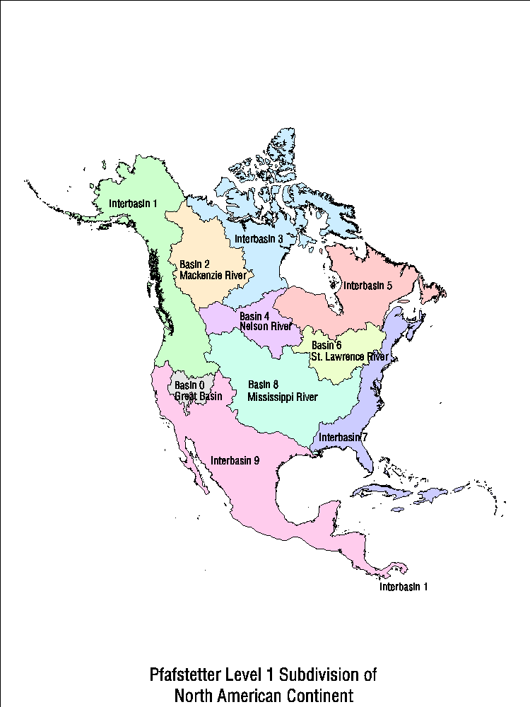
- I think that we can handle the spirit of the law with common sense, and the letter of the law with a drainage basin map like this as a source.
- I like that Pfly brings up the common quotation as a rare north-flowing river. If this is a common misconception and something in popular knowledge, it might be good to bring up as, "The St. Johns River is commonly cited as a rare North-flowing river in North America,[REF] though in fact many North American Rivers drain North into Hudson Bay and the Arctic Ocean.[REF]." Would this be acceptable to all? Awickert (talk) 18:33, 16 March 2010 (UTC)
- Ah, crap. I'm tired of dealing with this. What about putting a footnote in Upper basin, where it describes the river flowing north, to say that it is often cited as a rare instance of a river flowing north? Or something. If not, just get the gun and shoot the article. --Moni3 (talk) 18:49, 16 March 2010 (UTC)
- I think that would be an agreeable compromise - Considering Pfly's point - because the belief that north flowing rivers are rare and it is easily citable if you don't address it in some way it will keep being added back in and that it is a common belief may itself be notable and worth mentioning, but I think some counter point that it is not actually true is needed. Kmusser (talk) 19:04, 16 March 2010 (UTC)
- OK - finally did it. I'd be happy to make this a footnote instead, as it is sort of an aside, but I don't know how to give footnotes references. Awickert (talk) 05:18, 20 March 2010 (UTC)
The Bad Penny[edit]
The text in the article (Section Upper basin) reads: The river is frequently cited as being a rare north-flowing river in North America,[9][10] though in fact most of Canada and parts of the United States also drain north.[11][12]
Something like this should be placed in a note. Citation 11 links to here where "St. Johns" or "north" (lower case, used in direction, not proper name) does not appear. What passage is being cited in this document? Similarly, citation 12--what is being cited? It would appear these sources cite the fragment "though in fact most of Canada and parts of the United States also drain north". If so, that's not relevant to the St. Johns River.
After writing this article and returning to the same frustrating point, my thoughts about the issue are that a) the sources I use don't narrowly define what a northern flowing river is: the St. Johns is a N/S axis river. Is this what they mean? How many N/S axis rivers are there in North America that flow north? b) nobody knows what the hell anyone is talking about, or c) the entire argument is stupid and who really cares anyway?
At any rate, something this vague and wtf? needs to go to a footnote. If Awickert can point out what source info is being used in these citations, I might be able to construct one. --Moni3 (talk) 22:50, 2 December 2010 (UTC)
- My opinion is the same as it was earlier - I think the entire sentence should be deleted. Refs 11 and 12 are an attempt to cite the fact that north-flowing rivers are not rare, but I agree that it reads clumsily and neither really makes that point clearly - it's difficult to cite something for a negative statement. There are several hundred N/S axis rivers in the U.S. Every once in awhile someone will attempt to list them all, but they always get deleted (here and here). Kmusser (talk) 02:27, 3 December 2010 (UTC)
GA Review[edit]
- This review is transcluded from Talk:St. Johns River/GA1. The edit link for this section can be used to add comments to the review.
- It is well written.
- a (prose):
 a (MoS):
- a (prose):
- It follows the neutral point of view policy.
- Fair representation without bias:
- Fair representation without bias:
- It is stable.
- No edit wars etc.:
- No edit wars etc.:
- It is illustrated by images, where possible and appropriate.
- a (images are tagged and non-free images have fair use rationales): b (appropriate use with suitable captions):
- a (images are tagged and non-free images have fair use rationales):
- A few red links.

- It is factually accurate and verifiable.
- a (references): b (citations to reliable sources): c (OR):
- a (references):
Overall:![]() Pass. Secret Saturdays (talk) 21:20, 11 October 2009 (UTC)
Pass. Secret Saturdays (talk) 21:20, 11 October 2009 (UTC)
Stingrays[edit]
The existing source in the article is incorrect. The stingrays in the St. John's River are Atlantic stingrays, not southern stingrays. Here are just a few of the sources that support this: [2] [3] [4] [5] [6]. Some of these are scientific sources and thus more reliable on the subject. -- Yzx (talk) 20:39, 15 January 2010 (UTC)
- I agree. Thank you for the sources. I will change out the one listed for a more accurate one. --Moni3 (talk) 20:41, 15 January 2010 (UTC)
Source for river comment?[edit]
I started to delete the statement, The majority of rivers in the Northern Hemisphere tend to flow south towards the equator, probably caused by the force of the Earth's rotation. The St. Johns River is a notable exception, referenced to Benke. The equator [Earth's rotation (added 14:41, 16 March 2010 (UTC), accidentally wrote "equator" instead last night)] statement is horribly wrong (see edit comment), and I'm not so sure about the majority of NH rivers statement either: Mississippi/Missouri, Ganges-Brahmaputra, and Indus do, but the Lena, Nile, Churchill, and Mackenzie flow North, the Yukon flows North and West, and the Yellow flows squiggly and East. I'm deleting the whole thing for the moment (as per its being wrong), but I'd like to know what the source says in case we need to worry about its reliability in general, and/or get sources that don't make silly speculations. Awickert (talk) 06:22, 16 March 2010 (UTC)
- This is discussed further up on this page. I could demonstrate that "The majority of rivers in the Northern Hemisphere tend to flow south" is a false statement with about 5 minutes of OR, but can't source it, probably for the same reason I'd have trouble sourcing "water is wet", but there you go. Kmusser (talk) 14:23, 16 March 2010 (UTC)
- Yeah, that's the unfortunate and frustrating thing: nobody writes the obvious to disprove those who write the absurd :-(. Anyway, it's gone right now and will stay that way unless someone decides otherwise. Sorry for not looking at the earlier discussion and thanks for pointing it out; I was trying to burn through a review of this page and another one late last night. Awickert (talk) 14:39, 16 March 2010 (UTC)
Few more notes from St._Johns_River#Geologic_history[edit]
Each is signed for compartmentalized discussion. Awickert (talk) 06:44, 16 March 2010 (UTC)
- As ocean water retreated: Do we know when? Last glacial maximum? Awickert (talk) 06:44, 16 March 2010 (UTC)
- I removed the dates and geologic time-periods of the offset, because these didn't line up. Does anyone have the source to double-check these? Awickert (talk) 06:44, 16 March 2010 (UTC)
- "Trough created by Pangean rifting" --> I imagine that since these are earthquakes, this is continued activity along faults. (This is the case in New England, at least.) Awickert (talk) 06:44, 16 March 2010 (UTC)
- Awickert, I appreciate the time you took to look at the article. Since I struggle with geology, yet still find it interesting, some of the changes you made don't make sense to me. I don't understand why you removed some portions, such as What covers the peninsula is the result of simultaneous processes of deposits of sands, shells, and coral, and erosion from water and weather. As ocean water has retreated and progressed, the peninsula has been covered with sea water at least seven times. Waves compressed sands, calcium carbonate, and shells into limestone; at the ocean's edge, beach ridges were created by this depositional forming. That makes sense to me.
- I also don't understand why The majority of rivers in the Northern Hemisphere tend to flow south towards the equator, probably caused by the force of the Earth's rotation. The St. Johns River is a notable exception. was removed because it is cited twice from two excellent sources. Can you provide a source that states otherwise? This was discussed further up the page.
- I don't understand why has a long backwater, would have an effect on tides in the river. I find geology to be frustrating because it is often written completely in specific jargon making it inaccessible and the entire picture of the river incomplete. I was trying to avoid that in this article. Perhaps I oversimplified or otherwise stated something inaccurately in my attempts to make it understandable. Is there a way we can make it accurate yet still accessible? --Moni3 (talk) 12:11, 16 March 2010 (UTC)
- Mmmm... ok. The first one is the easiest to answer: I removed it because I couldn't tell when it happened / where in the story it should go, and wanted to discuss it with you (as we're doing now, yippee). In particular, I didn't know when the stated erosion would have occurred, or when the different inundations would have happened. Normal waves are only about 1-2 meters high, and their pressure can't squash a human body (which is fortunate!), let alone compress hard shells and sands. I think that what you are actually trying to describe is a reef environment, in which the organisms create limestone immediately (no extra lithification necessary); would this be correct? In any case, what I want geology sections to be like when I am done is a sort of chronological story that is generally accessible, and I couldn't make sense of the one that was here.
- For the rivers flowing south, I find it frustrating when what may be otherwise reliable sources say really dumb things and mislead readers. Because of Earth's rotation, the equatorial region is actually much higher in elevation than the rest of the planet. Imagine spinning a water balloon: it gets fat around the middle. We know that river always flow down potential gradient: that is, from areas that have high gravitational potential energy to those that have low. That is always (AFAIK) simply downhill, but if we're try to talk about the whole Earth and its rotation, we have to talk about the gravitational potential field, which is higher around the equator. Thus, if anything, rivers will be induced to flow north from the equator. But wait: there's more! Since all of the land masses are distorted into shape along this equatorial bulge (this being why the mountain furthest from the center of the Earth is in Ecuador), then rivers near the equator will not start lower. They will start comparably above a equipotential surface as their polar counterparts, and there will be therefore no difference between these rivers.
- I hope that made sense. I could provide references to show parts of that (I double-checked the physics in some just now), but would probably have to WP:SYN some things together because the standard issue is that nobody who knows what they're talking about would even think to mention or rebut an argument that the Earth's rotation causes streams in one hemisphere to flow towards the equator (this is the other issue: if it's rotation, Southern rivers should flow predominantly North, and I don't think that the facts bear that out).
- I have not tried to look for a source to say that the majority of Northern Hemisphere rivers flow south. That could be the case, though it would probably be an extremely weak signal in a lot of noise (see examples of major rivers flowing in different directions above). This would have to do with the positions and topographies of the continents. It seemed speculative and didn't feel safe sourcing it to the same people who had made a major physics error, so I removed it.
- Tides: I clearly didn't get this point across. What I was trying to write (and upon looking again, still think that I said) was that the tides rather have an effect on the river because of its long backwater caused by its shallow slope. The idea is that since the entire elevation drop of the river isn't that much greater than the daily tides, much of it will pool up and then flow quickly as the tides come in and go out. How would you say this? Awickert (talk) 15:22, 16 March 2010 (UTC)
What the section used to say:
Lying within a coastal plain, the St. Johns River passes through an area that was at one time barrier islands, coastal dunes, and estuary marshes. The Florida Peninsula was created primarily by forces and minerals from the ocean. It lies so low that minor fluctuations in sea levels can have a dramatic effect on its geomorphology. Florida was once part of the supercontinent Gondwana. Lying underneath the visible rock formations is a basement of igneous granite and volcanic composition under a sedimentary layer formed during the Paleozoic era 542 to 251 million years ago. During the Cretaceous period (145 to 65 million years ago), the basement and its sedimentary overlay were further covered by calcium carbonate and formations left by the evaporation of water called evaporites.[1] What covers the peninsula is the result of simultaneous processes of deposits of sands, shells, and coral, and erosion from water and weather.[2] As ocean water has retreated and progressed, the peninsula has been covered with sea water at least seven times. Waves compressed sands, calcium carbonate, and shells into limestone; at the ocean's edge, beach ridges were created by this depositional forming. North-south axis rivers, such as the St. Johns, were created by past beach ridges which were often divided by swales. As ocean water retreated, lagoons formed in the swales, which were further eroded by acidic water.[3] Barrier islands, furthermore, formed along the Atlantic Coast, surrounding the lagoon with land and forming a freshwater river.[4]
The majority of rivers in the Northern Hemisphere tend to flow south towards the equator, probably caused by the force of the Earth's rotation. The St. Johns River is a notable exception.[4] From its origins to approximately the area of Sanford, the St. Johns flows north.[5] It takes a sharp turn west near Sanford for a few miles—which is referred to as the St. Johns River offset, but shortly changes direction to flow north again. Geologists hypothesize that the west-flowing offset may have formed earlier than the north flowing portions, possibly during the late Tertiary or early Pleistocene era 65 to 12 million years ago. Some fracturing and faulting may also be responsible for the offset.[5] Although seismic activity in Florida is mostly insignificant, several minor earthquakes have occurred near the St. Johns River, caused by the trough created by Pangaean rifting.[6]
What it says now:
Florida was once part of the supercontinent Gondwana. During and after this time, in the Paleozoic era (542–251 million years ago), the geologic basement of igneous intrusive granites and extrusive (volcanic) rock, was covered by layers of sedimentary rock. During the Cretaceous period (145 to 65 million years ago), the basement and its sedimentary overlay were further covered by calcium carbonate and formations left by the evaporation of water called evaporites.[7]
Lying within a coastal plain, the St. Johns River passes through an area that was at one time barrier islands, coastal dunes, and estuary marshes. North-south axis rivers near coastal Florida, such as the St. Johns, have been steered into place by past beach ridges which were often divided by swales. As ocean water retreated, lagoons formed in the swales, which were further eroded by acidic water.[8]
From its origins to approximately the area of Sanford, the St. Johns flows north.[5] It takes a sharp turn west near Sanford for a few miles, but shortly changes direction to flow north again. This is referred to as the St. Johns River offset. Geologists hypothesize that the west-flowing offset may have formed earlier than the north flowing portions.[5] Although seismic activity in Florida is mostly insignificant, several minor earthquakes have occurred near the St. Johns River, caused by the trough created by Pangaean rifting.[9]
Most significant changes:
- The formation of the Florida peninsula was removed making the paragraph so simplistic as to be nearly meaningless. It excludes discussion of what calcium carbonate comes from: depositional forming of sand, shells, and coral pressed by the weight of ocean water. There is no mention of limestone that was created by deposits of calcium carbonate and erosion by weather.
- There is no opening or topic sentence.
- Most references to geologic periods are removed.
I do not know why these changes were made. They are sourced and are clearly pertinent to the topic. If they are inaccurate or should be reworded, then let's figure out how to reword them. Please provide your reasons (hopefully with a source) that says why these changes should remain in the article. As it stands now, this section is not FA quality and should be remedied. I apologize for taking so long to get back to this. I'm trying to take small steps to return to regular editing. --Moni3 (talk) 13:21, 7 May 2010 (UTC)
- I agree, the former looked and reads much better. Ouch... - The Bushranger Return fireFlank speed 16:55, 7 May 2010 (UTC)
References
NPOV[edit]
While undoubtably an environmental calamity, the section discussing the Cross Florida Barge Canal seems, to me at least, to have verbiage that goes a bit over the top for an encyclopedia article. Thoughts? - The Bushranger (talk) 07:34, 29 March 2010 (UTC)
- "The most egregious" sounds a little too strong. The rest of the section could use some prose work too. So if you're willing to take the time, please go ahead! Awickert (talk) 07:46, 29 March 2010 (UTC)
- Why does "the most egregious" sound a little too strong? It has a note attached to it saying it was "probably the single most dangerous threat to the water resources of the state in the twentieth century". Governor Claude Kirk and President Richard Nixon both opposed the canal with Nixon finally putting a halt to construction in 1971. A Reader's Digest article in 1970 brought nationwide attention to it in an article titled "Rape of the Ocklawaha". The canal never had any solid justification to be constructed other than porkbarrel politics.
- You don't like the word egregious, although it is justified? Pick another word that conveys how serious and foolhardy the construction of the canal was. It's almost as if the word "egregious" in your thesaurus has {{NPOV}} next to it. That's all that needs to be done, yet the NPOV tag stays on the article. --Moni3 (talk) 19:56, 11 April 2010 (UTC)
- Pardon. The way I write, impacts are large, and effects are egregious. It's subtle. I didn't put the NPOV tag there, incidentally, and don't have a large opinion on it (hence "a little"). Since The Bushranger hasn't done anything, I'll remove it and work on the rest of the section. Awickert (talk) 20:22, 11 April 2010 (UTC)
- A question about one sentence: "Flood control was the primary impetus behind its construction, though the broader reasoning and feasibility of the project remained unclear." (I reworded it, hope you think it's an OK way to say it.) This has no explicit source, and it would be nice to be able to give specific examples of what in the feasibility study, etc., was the problem. Awickert (talk) 20:33, 11 April 2010 (UTC)
Average < Minimum?[edit]
I'm trying to understand how the average discharge of the river could be less that the minimum discharge of the river. - Jlodman (talk) 17:21, 25 July 2010 (UTC)
- Are you going on the infobox only? It's explained in the Flow rates and water quality section. Is that unclear? Infoboxes demand simple numbers when sometimes it's just not simple. I dislike infoboxes for that reason. --Moni3 (talk) 00:52, 26 July 2010 (UTC)
- Heh, good catch. The source cited says "total flow in the river is comprised of about 80%-90% tide-induced flow", and that "total discharge of the river is normally greater than 50,000 cfs and can exceed 150,000 cfs... The average annual nontidal discharge at the river mouth is approximately 15,000 cfs." So it doesn't exactly make sense to me for the minimum discharge to be put as 50,000 cfs--that figure is what the discharge is "normally greater than". Also, these figures are pretty vague. Perhaps it would be better to use USGS stream gage data? The gage closest to the river's mouth that has discharge statistics seems to be 02246500 St. Johns River at Jacksonville, FL. It gives the average/mean discharge as 8,603 cfs, the maximum as 120,000, and the minimum as -69,200 cfs. The negative figure is "reverse flow", due to tides. There's a similar negative discharge minimum stat on the Columbia Slough page (an FA article--it has a short little discharge subsection explaining things a little more). Discharge stats for tidally influenced rivers can be pretty weird. I was going to be bold and use the USGS figures instead, but Moni3 posted just before I was going to and gave me pause. So I'll just ask: wouldn't it be better to use the USGS figures? If nothing else they are more up to date. Pfly (talk) 01:26, 26 July 2010 (UTC)
- I've never seen this stream gage data. I'm all in for the night, so I can't make any sense of it. If there are obvious weaknesses, then we should discuss how to make the article as accurate as possible, but the source used for the Flow rate paragraph is from NOAA so I'm not ready to toss it out. Let me take a look at it tomorrow when I'm clearer. --Moni3 (talk) 01:32, 26 July 2010 (UTC)
- Hmm, yea, it's nice that it's NOAA, and about the flow at the mouth itself. If I'm reading the page right the source for the discharge estimates is this paper, published by the NOAA and citing a 1985 NOAA report for the discharge info: "National Oceanic and Atmospheric Administration, 1985. National Estuarine Inventory, Data Atlas. Volume 1, Physical and Hydrologic Characteristics. National Ocean Service. Rockville, MD." It looks like the NOAA data is still actively compiled and available, and probably more current, but probably in GIS format. This NOAA page describes what seems to be the same basic data collection cited in the USGS paper. It's interesting that the page says NOAA gets "freshwater inflow" data from USGS stream gages and "tidal range and tidal prism volume" from NOS tide stations. I can't quite figure out right now whether the USGS stream gage or the NOAA estuarine inventory data would be most appropriate. The topic gets complicated fast. There are a few Wikipedia pages that help (sort of): tidal range, tidal prism, Inflow (hydrology), Discharge (hydrology), and Streamflow. Anyway, my sense is that the USGS stream gage data might be more appropriate than the NOAA estuarine data, but I'm not an expert on this topic (just weirdly fascinated). If nothing else the infobox's minimum of 50,000 cfs doesn't seem right, even according to the NOAA source. Also, despite my babbling, please feel free to brush all this aside as unnecessary, time-consuming, trivial, and arcane. The infobox's min field could just be left blank and all would be fine. Pfly (talk) 04:59, 26 July 2010 (UTC)
- I read the section on flow rates and it offers nothing of any value to understand how the infobox average can be less than the minimum. It is apparent from reading that section that the 50,000 figure quoted as the minimum is in fact not a minimum at all. It is a number that apparently refers to the maximum of a non-rain condition plus maximum tidal effects. In any case, the infobox is clearly in error on this point.Jlodman (talk) 06:13, 29 July 2010 (UTC)
Infobox move[edit]
This article presently uses a sub-template to hold its infobox contents. This makes it more difficult to keep the article and infobox in sync, and it's not much of a maintainability gain considering that the infobox is only ~3k or so. I reckon it should be moved back in here. Chris Cunningham (user:thumperward: not at work) - talk 13:49, 24 August 2010 (UTC)
- I don't understand how it's difficult to maintain the infobox. It's quite easy actually. If anything should be done to the infobox, it should be removed entirely. --Moni3 (talk) 11:43, 25 August 2010 (UTC)
Unit conversion error[edit]
It is stated in the article that "the St. Johns has a very slow flow rate at a third of a mile an hour (0.2 km/h)". One of the two figures must be wrong : a third of a mile is in fact 0.5 km. However, either 1/3 mile is false, either 0.2 km. 130.92.9.55 (talk) 17:54, 17 November 2010 (UTC)
This is a pretty bad image. I can't see what it is (even when expanded to 350 px, which it should not be), and as it stands currently, probably should not be in a featured article. Tony, can you find a replacement of better quality?
Also, placing this image in the same section where the map is sandwiches the text, squeezing it together, which should be avoided, and which I would be told to fix immediately during FAC. Do you have a suggestion about how to fix this? --Moni3 (talk) 14:24, 5 June 2011 (UTC)
After a few days and no reply, I'm going to maintain the FA quality of this article and remove the image. --Moni3 (talk) 13:47, 11 June 2011 (UTC)
Propose adding mention of National Research Council reports on St. Johns River?[edit]
A series of reports from the United States National Research Council review a St. Johns River Water Management District study of the possible ecological impacts of using the St. Johns River as a source of public water. The report can be found here: http://dels.nas.edu/Report/Review-Johns-River/13314
Could we add some text on this? How about:
- The St. Johns River is under consideration as an additional water source to meet growing public water needs. In 2008, the river's Water Management District undertook a Water Supply Impact Study of the proposed water withdrawals and asked the National Research Council to review science aspects of the study as it progressed. This resulted in a series of four reports that assessed the impact of water withdrawal on river level and flow, reviewed potential impacts on wetland ecosystems, and presented overall perspectives on the Water Management District study [1]. The National Research Council found that, overall, the District performed a competent job in relating predicted environmental responses, including their magnitude and general degree of uncertainty, to the proposed range of water withdrawals. However, the report noted that the District’s final report should acknowledge such critical issues as include future sea-level rises, population growth, and urban development. Although the District predicted that changes in water management would increase water levels and flows that exceed the proposed surface water withdrawals, these predictions have have high uncertainties. [2]
- The report also noted concerns about the District's conclusion that the water withdrawals will have few deleterious ecological effects. This conclusion was based on the model findings that increased flows from upper basin projects and from changes in land use (increases in impervious areas) largely compensated for the impacts of water withdrawals on water flows and levels. Although the upper basin projects are positive insofar as they will return land to the basin (and water to the river), the same cannot be said about increased urban runoff, the poor quality of which is well-known.[3]
I'd welcome any feedback. Earlgrey101 (talk) 22:35, 23 March 2012 (UTC)
References
TFAR[edit]
Wikipedia:Today's featured article/requests/St. Johns River --Gerda Arendt (talk) 13:23, 11 October 2015 (UTC)
External links modified[edit]
Hello fellow Wikipedians,
I have just added archive links to one external link on St. Johns River. Please take a moment to review my edit. If necessary, add {{cbignore}} after the link to keep me from modifying it. Alternatively, you can add {{nobots|deny=InternetArchiveBot}} to keep me off the page altogether. I made the following changes:
- Added archive https://web.archive.org/20110716143602/http://www.stjohnsriveralliance.com/waterwithdrawl.pdf to http://www.stjohnsriveralliance.com/waterwithdrawl.pdf
When you have finished reviewing my changes, please set the checked parameter below to true to let others know.
This message was posted before February 2018. After February 2018, "External links modified" talk page sections are no longer generated or monitored by InternetArchiveBot. No special action is required regarding these talk page notices, other than regular verification using the archive tool instructions below. Editors have permission to delete these "External links modified" talk page sections if they want to de-clutter talk pages, but see the RfC before doing mass systematic removals. This message is updated dynamically through the template {{source check}} (last update: 18 January 2022).
- If you have discovered URLs which were erroneously considered dead by the bot, you can report them with this tool.
- If you found an error with any archives or the URLs themselves, you can fix them with this tool.
Cheers. —cyberbot IITalk to my owner:Online 04:51, 19 October 2015 (UTC)
External links modified[edit]
Hello fellow Wikipedians,
I have just modified 7 external links on St. Johns River. Please take a moment to review my edit. If you have any questions, or need the bot to ignore the links, or the page altogether, please visit this simple FaQ for additional information. I made the following changes:
- Added archive https://web.archive.org/web/20091005131503/http://www.protectingourwater.org/watersheds/map/upper_st_johns/ to http://www.protectingourwater.org/watersheds/map/upper_st_johns/
- Added archive https://web.archive.org/web/20091005131347/http://www.protectingourwater.org/watersheds/map/middle_st_johns/ to http://www.protectingourwater.org/watersheds/map/middle_st_johns/
- Added archive https://web.archive.org/web/20091005131342/http://www.protectingourwater.org/watersheds/map/lower_st_johns/ to http://www.protectingourwater.org/watersheds/map/lower_st_johns/
- Added archive https://web.archive.org/web/20091005131342/http://www.protectingourwater.org/watersheds/map/lower_st_johns/ to http://www.protectingourwater.org/watersheds/map/lower_st_johns/
- Added archive https://web.archive.org/web/20091005131347/http://www.protectingourwater.org/watersheds/map/middle_st_johns/ to http://www.protectingourwater.org/watersheds/map/middle_st_johns/
- Added archive https://web.archive.org/web/20091005131503/http://www.protectingourwater.org/watersheds/map/upper_st_johns/ to http://www.protectingourwater.org/watersheds/map/upper_st_johns/
- Added archive https://web.archive.org/web/20060813002433/http://sjr.state.fl.us/ to http://sjr.state.fl.us/
When you have finished reviewing my changes, you may follow the instructions on the template below to fix any issues with the URLs.
This message was posted before February 2018. After February 2018, "External links modified" talk page sections are no longer generated or monitored by InternetArchiveBot. No special action is required regarding these talk page notices, other than regular verification using the archive tool instructions below. Editors have permission to delete these "External links modified" talk page sections if they want to de-clutter talk pages, but see the RfC before doing mass systematic removals. This message is updated dynamically through the template {{source check}} (last update: 18 January 2022).
- If you have discovered URLs which were erroneously considered dead by the bot, you can report them with this tool.
- If you found an error with any archives or the URLs themselves, you can fix them with this tool.
Cheers.—InternetArchiveBot (Report bug) 19:16, 20 May 2017 (UTC)
External links modified[edit]
Hello fellow Wikipedians,
I have just modified one external link on St. Johns River. Please take a moment to review my edit. If you have any questions, or need the bot to ignore the links, or the page altogether, please visit this simple FaQ for additional information. I made the following changes:
- Added archive https://web.archive.org/web/20090608195157/http://www.protectingourwater.org/watersheds/map/ocklawaha/ to http://www.protectingourwater.org/watersheds/map/ocklawaha/
When you have finished reviewing my changes, you may follow the instructions on the template below to fix any issues with the URLs.
This message was posted before February 2018. After February 2018, "External links modified" talk page sections are no longer generated or monitored by InternetArchiveBot. No special action is required regarding these talk page notices, other than regular verification using the archive tool instructions below. Editors have permission to delete these "External links modified" talk page sections if they want to de-clutter talk pages, but see the RfC before doing mass systematic removals. This message is updated dynamically through the template {{source check}} (last update: 18 January 2022).
- If you have discovered URLs which were erroneously considered dead by the bot, you can report them with this tool.
- If you found an error with any archives or the URLs themselves, you can fix them with this tool.
Cheers.—InternetArchiveBot (Report bug) 19:56, 24 June 2017 (UTC)
External links modified[edit]
Hello fellow Wikipedians,
I have just modified 10 external links on St. Johns River. Please take a moment to review my edit. If you have any questions, or need the bot to ignore the links, or the page altogether, please visit this simple FaQ for additional information. I made the following changes:
- Added archive https://web.archive.org/web/20060201012634/http://www.epa.gov/rivers/plan/stjohn1.pdf to http://www.epa.gov/rivers/plan/stjohn1.pdf
- Added
{{dead link}}tag to http://sjr.state.fl.us/publications/pdfs/fs_sjrbigpicture.pdf - Added archive https://web.archive.org/web/20100116085805/http://proceedings.esri.com/library/userconf/proc97/proc97/to350/pap311/p311.htm to http://proceedings.esri.com/library/userconf/proc97/proc97/to350/pap311/p311.htm
- Added
{{dead link}}tag to http://sjr.state.fl.us/publications/pdfs/fs_msjrb.pdf - Added archive https://web.archive.org/web/20060201012642/http://www.epa.gov/rivers/plan/stjohn2.pdf to http://www.epa.gov/rivers/plan/stjohn2.pdf
- Added archive https://web.archive.org/web/20111002190645/http://www.kingfishtournament.com/rules_gt.php to http://www.kingfishtournament.com/rules_gt.php
- Added archive https://web.archive.org/web/20090315112507/http://sjr.state.fl.us/springs/marion/silver.html to http://sjr.state.fl.us/springs/marion/silver.html
- Added archive https://web.archive.org/web/20090504113900/http://sjr.state.fl.us/springs/marion/silver_glen.html to http://sjr.state.fl.us/springs/marion/silver_glen.html
- Added archive https://web.archive.org/web/20090524074735/http://sjr.state.fl.us/springs/lake/alexander.html to http://sjr.state.fl.us/springs/lake/alexander.html
- Added archive https://web.archive.org/web/20090315112512/http://sjr.state.fl.us/springs/volusia/blue.html to http://sjr.state.fl.us/springs/volusia/blue.html
- Added archive https://web.archive.org/web/20090625062112/http://sjr.state.fl.us/minimumflowsandlevels/bluespring/index.html to http://sjr.state.fl.us/minimumflowsandlevels/bluespring/index.html
- Added archive https://web.archive.org/web/20090831174528/http://www.epa.gov/rivers/eo13061.html to http://www.epa.gov/rivers/eo13061.html
When you have finished reviewing my changes, you may follow the instructions on the template below to fix any issues with the URLs.
This message was posted before February 2018. After February 2018, "External links modified" talk page sections are no longer generated or monitored by InternetArchiveBot. No special action is required regarding these talk page notices, other than regular verification using the archive tool instructions below. Editors have permission to delete these "External links modified" talk page sections if they want to de-clutter talk pages, but see the RfC before doing mass systematic removals. This message is updated dynamically through the template {{source check}} (last update: 18 January 2022).
- If you have discovered URLs which were erroneously considered dead by the bot, you can report them with this tool.
- If you found an error with any archives or the URLs themselves, you can fix them with this tool.
Cheers.—InternetArchiveBot (Report bug) 12:04, 24 September 2017 (UTC)
External links modified[edit]
Hello fellow Wikipedians,
I have just modified 5 external links on St. Johns River. Please take a moment to review my edit. If you have any questions, or need the bot to ignore the links, or the page altogether, please visit this simple FaQ for additional information. I made the following changes:
- Added archive https://web.archive.org/web/20071027234557/http://www.sjrwmd.com/publications/pdfs/fs_otters.pdf to http://www.sjrwmd.com/publications/pdfs/fs_otters.pdf
- Added archive https://web.archive.org/web/20071028002538/http://www.sjrwmd.com/publications/pdfs/fs_lapopka.pdf to http://www.sjrwmd.com/publications/pdfs/fs_lapopka.pdf
- Added archive https://web.archive.org/web/20160610114847/http://www.sjrwmd.com/stjohnsriver/facts.html to http://www.sjrwmd.com/stjohnsriver/facts.html
- Added archive https://web.archive.org/web/20090731100438/http://www.sjrwmd.com/publications/pdfs/fs_minflowlevels.pdf to http://www.sjrwmd.com/publications/pdfs/fs_minflowlevels.pdf
- Added archive https://web.archive.org/web/20110514201922/http://www.dep.state.fl.us/gwt/cfg/pdf/History_Report.pdf to http://www.dep.state.fl.us/gwt/cfg/pdf/History_Report.pdf
When you have finished reviewing my changes, you may follow the instructions on the template below to fix any issues with the URLs.
This message was posted before February 2018. After February 2018, "External links modified" talk page sections are no longer generated or monitored by InternetArchiveBot. No special action is required regarding these talk page notices, other than regular verification using the archive tool instructions below. Editors have permission to delete these "External links modified" talk page sections if they want to de-clutter talk pages, but see the RfC before doing mass systematic removals. This message is updated dynamically through the template {{source check}} (last update: 18 January 2022).
- If you have discovered URLs which were erroneously considered dead by the bot, you can report them with this tool.
- If you found an error with any archives or the URLs themselves, you can fix them with this tool.
Cheers.—InternetArchiveBot (Report bug) 20:52, 20 October 2017 (UTC)
External links modified (February 2018)[edit]
Hello fellow Wikipedians,
I have just modified 3 external links on St. Johns River. Please take a moment to review my edit. If you have any questions, or need the bot to ignore the links, or the page altogether, please visit this simple FaQ for additional information. I made the following changes:
- Added archive https://web.archive.org/web/20100316054402/http://jacksonville.com/tu-online/stories/073108/lif_311065844.shtml to http://www.jacksonville.com/tu-online/stories/073108/lif_311065844.shtml
- Added archive https://web.archive.org/web/20080705162754/http://www.jacksonville.com/tu-online/stories/041708/met_269111418.shtml to http://www.jacksonville.com/tu-online/stories/041708/met_269111418.shtml
- Added archive https://web.archive.org/web/20080705133726/http://www.jacksonville.com/tu-online/stories/041808/opl_269404251.shtml to http://www.jacksonville.com/tu-online/stories/041808/opl_269404251.shtml
When you have finished reviewing my changes, you may follow the instructions on the template below to fix any issues with the URLs.
This message was posted before February 2018. After February 2018, "External links modified" talk page sections are no longer generated or monitored by InternetArchiveBot. No special action is required regarding these talk page notices, other than regular verification using the archive tool instructions below. Editors have permission to delete these "External links modified" talk page sections if they want to de-clutter talk pages, but see the RfC before doing mass systematic removals. This message is updated dynamically through the template {{source check}} (last update: 18 January 2022).
- If you have discovered URLs which were erroneously considered dead by the bot, you can report them with this tool.
- If you found an error with any archives or the URLs themselves, you can fix them with this tool.
Cheers.—InternetArchiveBot (Report bug) 06:31, 18 February 2018 (UTC)
- Wikipedia featured articles
- Featured articles that have appeared on the main page
- Featured articles that have appeared on the main page once
- Old requests for peer review
- Wikipedia Did you know articles that are featured articles
- FA-Class Florida articles
- High-importance Florida articles
- WikiProject Florida articles
- FA-Class River articles
- Mid-importance River articles