
Tadiandamol
| Tadiandamol | |
|---|---|
 Sholas grassland viewed from Tadiandamol peak | |
| Highest point | |
| Elevation | 1,748 m (5,735 ft) |
| Coordinates | 12°13′3.2308″N 75°36′31.7340″E / 12.217564111°N 75.608815000°E |
| Geography | |
 Tadiandamol Location of Tadiandamol, Karnataka  Tadiandamol Tadiandamol (India) | |
| Location | Madikeri Taluk , Kodagu District, Karnataka, India |
| Parent range | Western Ghats |
| Climbing | |
| Easiest route | Hike |
Tadiandamol or Thadiyandamol is the highest mountain of Madikeri taluk Kodagu district, Karnataka, India. It is the third highest peak in Karnataka, after Mullayyanagiri & Kudremukha.[1] It is located Western Ghats range, and reaches an elevation of 1,748 m. The mountain has patches of shola forests in the valleys.
The Nalaknad (also known as Nalnad - meaning 4 villages) palace at the foothills is an important historical landmark. This was one of the landmarks mapped during the Great Trigonometric Survey.
It is a place of interest for trekkers and naturalists. The climb to the top and back can be completed as a day hike(within 5hrs) and the entry is closed at 5:00 pm; camping is banned since December 2016.The best time to visit the peak is July-end to September(after monsoon) as greenery is observed well in these months.
Etymology[edit]
The name Tadiandamol literally means largest base (thadi = broad, large, huge; anda = belonging to (possessive) in Kodava; mol = hill, base, peak). It loosely means Tallest Mount,[2] and the name also could translate as Broad Hill.[3]
Gallery[edit]
-
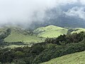
 View from Tadiandamol Peak during august end
 -
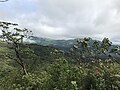
 View from Tadiandamol Peak
 -
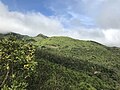
 Greenery seen from Tadiandamol Peak
 -
 View From Second Topmost hill during Tadiandamol trekking
 -
 checkpost and starting point of Tadiandamol Trek
 -
 checkpost and starting point of Tadiandamol Trek pic 2
 -
 Tadiandamol Trekking starting point view from Resort
 -
 Tadiandamol Trek View from 2nd viewpoint


See also[edit]
References[edit]
- ^ "Trekking These Highest Karnataka Peaks Will Make Your Friends Envy".
- ^ "Codagu.org".
- ^ Surendra Rao, B. (1998). "Google books".
External links[edit]
 Media related to Tadiandamol at Wikimedia Commons