
Tubbergen
Tubbergen
Tubbige (Twents) | |
|---|---|
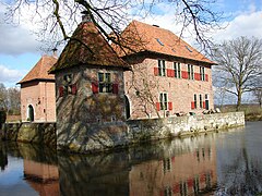
 Former city hall of Tubbergen | |
 Flag  Coat of arms | |
.svg) Location in Overijssel | |
| Coordinates: 52°24′N 6°47′E / 52.400°N 6.783°E | |
| Country | Netherlands |
| Province | Overijssel |
| Government | |
| • Body | Municipal council |
| • Mayor | Anko Postma (No party) |
| Area | |
| • Total | 147.44 km2 (56.93 sq mi) |
| • Land | 147.00 km2 (56.76 sq mi) |
| • Water | 0.44 km2 (0.17 sq mi) |
| Elevation | 22 m (72 ft) |
| Population (January 2021)[4] | |
| • Total | 21,315 |
| • Density | 145/km2 (380/sq mi) |
| Demonym(s) | Tubbergenaar, Tubberger |
| Time zone | UTC+1 (CET) |
| • Summer (DST) | UTC+2 (CEST) |
| Postcode | 7614–7619, 7650–7669, 7679 |
| Area code | 0541, 0546 |
| Website | www |
 | |
Tubbergen (Dutch: [tʏˈbɛrɣə(n)] ; Tweants: Tubbige) is a municipality and town in the province of Overijssel in the eastern Netherlands.
Geography[edit]
The following population centres can be found in Tubbergen:
Politics[edit]
At the 2022 municipal elections, the 19-seat municipal council of Tubbergen was composed as follows.[5]
| Party | Popular vote | Seats | ||
|---|---|---|---|---|
| Votes | % | |||
| Christian Democratic Appeal (CDA) | 3,230 | 29.33 | 6 / 19
| |
| Gemeentebelangen / VVD (GB/VVD) | 2,972 | 26.98 | 5 / 19
| |
| Keerpunt22 | 2,180 | 19.79 | 4 / 19
| |
| Lokaal Sterk | 1,957 | 17.77 | 3 / 19
| |
| Labour Party (PvdA) | 675 | 6.13 | 1 / 19
| |
Society[edit]
The municipality has a high birth rate and the lowest divorce rate in the Netherlands.[citation needed] Politically, Tubbergen has one of the largest shares of Christian Democratic Appeal voters at 61.29% in 2018,[6] although this dropped to 29.33% in 2022.
According to a 2009 survey by the Algemeen Dagblad, Tubbergen has the lowest crime rate of all municipalities in the Netherlands. According to the mayor, this is primarily because of a strong sense of community.[citation needed]
Notable people[edit]

- Clemens Maria Franz von Bönninghausen (1785 near Fleringen – 1864) a lawyer, Dutch and Prussian civil servant, agriculturalist, botanist, physician and pioneer in the field of homeopathy
- Herman Schaepman (1844 in Tubbergen – 1903) a Dutch priest, politician and poet [7]
- Gerard Bruggink (1917 in Tubbergen – 2005) a Dutch pilot of the Royal Netherlands East Indies Army Air Force
Sport[edit]
- Berny Boxem-Lenferink (1948 in Tubbergen– 2023) a Dutch middle-distance runner, competed at the 1972 Summer Olympics
- Gerco Schröder (born 1978 in Tubbergen) a Dutch show jumping equestrian, participated at the 2004 Summer Olympics
- Nicole Oude Luttikhuis (born 1997 in Harbrinkhoek) a Dutch volleyball player, participated in the Dutch national women's volleyball team
Gallery[edit]
-
 Sint-Pancratius basiliek, Tubbergen
 -
 House in Breckelenkamp
 -
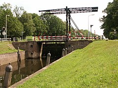 Reutum, lock on the Almelo-Nordhorn canal
 -
 Sint Pancratiuskerk Albergen


References[edit]
- ^ "Burgemeester Anko Postma" (in Dutch). Gemeente Tubbergen. Archived from the original on 3 October 2023. Retrieved 22 May 2024.
- ^ "Kerncijfers wijken en buurten 2020" [Key figures for neighbourhoods 2020]. StatLine (in Dutch). CBS. 24 July 2020. Retrieved 19 September 2020.
- ^ "Postcodetool for 7651CV". Actueel Hoogtebestand Nederland (in Dutch). Het Waterschapshuis. Retrieved 1 April 2014.
- ^ "Bevolkingsontwikkeling; regio per maand" [Population growth; regions per month]. CBS Statline (in Dutch). CBS. 1 January 2021. Retrieved 2 January 2022.
- ^ "Tubbergen municipal election 2022". verkiezingsuitslagen.nl (in Dutch). 16 March 2022. Retrieved 22 May 2024.
- ^ "Gemeenteraad 21 maart 2018". Verkiezingsuitslagen (in Dutch). Retrieved 17 November 2018.
- ^ Albers, Petrus Henricus (1912). . Catholic Encyclopedia. Vol. 13.
External links[edit]
Places adjacent to Tubbergen | ||||||||||||||||
|---|---|---|---|---|---|---|---|---|---|---|---|---|---|---|---|---|
| ||||||||||||||||
Overijssel province | ||
|---|---|---|
| Municipalities |  | |
| Regions | ||
| International | |
|---|---|
| National | |
This Overijssel location article is a stub. You can help Wikipedia by expanding it. |