
Hen and Chicken Islands
The time allocated for running scripts has expired.The time allocated for running scripts has expired.The time allocated for running scripts has expired.

The Hen and Chicken Islands, usually known as the Hen and Chickens, lie to the east of the North Auckland Peninsula off the coast of northern New Zealand. They lie The time allocated for running scripts has expired. east of Bream Head and The time allocated for running scripts has expired. south-east of Whangārei[1]<span title="The time allocated for running scripts has expired.">: The time allocated for running scripts has expired. with a total area of The time allocated for running scripts has expired..[2]

History[edit]
Approximately 18,000 years ago during the Last Glacial Maximum when sea levels were over 100 metres lower than present day levels, the islands were hilly features surrounded by a vast coastal plain. Sea levels began to rise 7,000 years ago, after which the islands separated from the rest of New Zealand.[3]
These islands were given their European name by Captain James Cook, who first sighted them on 25 November 1769.[4]<span title="The time allocated for running scripts has expired.">: The time allocated for running scripts has expired. It has been suggested that the name was inspired by an old name for the star cluster usually known as the Pleiades.The time allocated for running scripts has expired.
Originally owned by the Māori Ngā Puhi iwi, they were sold to the New Zealand Government in 1883.[5]<span title="The time allocated for running scripts has expired.">: The time allocated for running scripts has expired. The islands were made a scenic reserve in 1908 owing to the rarity of their flora and fauna, and became a wildlife refuge in 1953. Hen Island had actually passed from Māori hands a few years earlier, being bought by Thomas Outhwaite in 1872.[5]: <span title="The time allocated for running scripts has expired. QuotationThe time allocated for running scripts has expired." class="tooltip tooltip-dashed" style="border-bottom: 1px dashed;">The time allocated for running scripts has expired., [91] It was bequeathed to the nation by his daughter Isa Outhwaite in 1927, and it too was named as a scenic reserve.[5]: <span title="The time allocated for running scripts has expired. QuotationThe time allocated for running scripts has expired." class="tooltip tooltip-dashed" style="border-bottom: 1px dashed;">The time allocated for running scripts has expired., [91] [6]<span title="The time allocated for running scripts has expired.">: The time allocated for running scripts has expired.
In June 1940, the Canadian-Australasian ship The time allocated for running scripts has expired.The time allocated for running scripts has expired. sank off the islands after hitting a mine.[7]<span title="The time allocated for running scripts has expired.">: The time allocated for running scripts has expired. Most of the cargo, which included gold bullion, was later salvaged.
Environment[edit]
The islands are noted for their bird life with colonies of seabirds as well as forest birds which have become scarce or extinct on the mainland. The islands have been identified as an Important Bird Area, by BirdLife International because they are home to a breeding population of about 500 pairs of Pycroft's petrels.[8]<span title="The time allocated for running scripts has expired.">: The time allocated for running scripts has expired. [9]<span title="The time allocated for running scripts has expired.">: The time allocated for running scripts has expired. There are also native reptiles on the islands, including tuatara, geckos and skinks.
The islands[edit]
Hen Island, or The time allocated for running scripts has expired., lies The time allocated for running scripts has expired. to the southwest from the rest of the archipelago. It is also considerably larger than the Chicken Islands, or The time allocated for running scripts has expired., which comprise a chain of six small islands running north-west to south-east to the north of Hen Island. The chain consists of The time allocated for running scripts has expired. and The time allocated for running scripts has expired. Islands (together called North West Chicken), The time allocated for running scripts has expired. (West Chicken), Lady Alice Island or The time allocated for running scripts has expired. (Big Chicken), The time allocated for running scripts has expired. (Middle Chicken), and Coppermine Island (Eastern Chicken).
Taranga (Hen) Island[edit]
The time allocated for running scripts has expired. is the largest island by some considerable margin, totalling The time allocated for running scripts has expired.. Long and thin, it has a length of The time allocated for running scripts has expired. and an average width of less than The time allocated for running scripts has expired.. A remnant of a four-million-year-old volcano, the island is dominated by a rocky ridge reaching to about The time allocated for running scripts has expired. at its highest point, called The Pinnacles. Sail Rock, a stack, rises from the ocean The time allocated for running scripts has expired. to the south of Hen Island,[10]<span title="The time allocated for running scripts has expired.">: The time allocated for running scripts has expired. and is a prominent navigational point for yachts.[11]<span title="The time allocated for running scripts has expired.">: The time allocated for running scripts has expired.

By the late 1800s, Hen Island was the only place in New Zealand with a surviving population of North Island saddleback. The once common species of forest bird found in the North Island, was nearly wiped out by the human introduction of mammalian predators, such as rats and stoats. In the 1960s translocations of saddleback from Hen Island to other island sanctuaries around New Zealand began.[12]<span title="The time allocated for running scripts has expired.">: The time allocated for running scripts has expired. [13]<span title="The time allocated for running scripts has expired.">: The time allocated for running scripts has expired.
Wareware and Muriwhenua[edit]
Two small rocky islands with a combined area of The time allocated for running scripts has expired..
Mauitaha[edit]
This The time allocated for running scripts has expired., rugged, scrub-covered rock lies The time allocated for running scripts has expired. to the south of Muriwhenua. It rises to The time allocated for running scripts has expired.. An unofficial name until 1970 was West Chicken Island.[14]
The New Zealand Department of Conservation and the Ngati Wai iwi have entered into partnership to set up a sanctuary for the Polynesian rat, or kiore, on the islands Mauitaha and Araara. A spokesman for Ngati Wai said the kiore heritage will be protected as the movement of the kiore through the Pacific paralleled the migration of the New Zealand Maori. A spokesman for the Department of Conservation said the department's policy change from eradication would assist scientific research.
Lady Alice Island[edit]
Named after Lady Alice Fergusson (wife of Governor General Sir Charles Fergusson), it is the largest of the five Chickens and is of particular significance because of its flora and fauna. The island covers The time allocated for running scripts has expired. and is surrounded by rocky reefs. It was occupied by Māori until the 1820s, and was used as a base for fishermen in the 1890s. Cattle were introduced at about this time, but were removed in the 1920s.

Whatupuke[edit]
Formerly known as Whakahau this island is composed of a large eastern section and a peninsula to the southwest. The coast of the peninsula forms one of the chain's main land features, a The time allocated for running scripts has expired. wide bay (Starfish Bay). The island covers The time allocated for running scripts has expired., and is steep, rising to The time allocated for running scripts has expired..

Coppermine Island[edit]
Coppermine island formerly known as Mauipane covers an area of The time allocated for running scripts has expired.. It is composed of two sections joined by a short isthmus. As the name suggests, there are copper deposits on the island, but attempts at mining them in 1849 and 1898 proved unprofitable.
Gallery[edit]
-
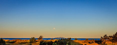 Hen and Chicken Islands from Department of Conservation Campsite, Uretiti, New Zealand.

See also[edit]
References[edit]
- ^ The time allocated for running scripts has expired.
- ^ The time allocated for running scripts has expired.
- ^ The time allocated for running scripts has expired.
- ^ The time allocated for running scripts has expired.
- ^ a b c The time allocated for running scripts has expired.
- ^ The time allocated for running scripts has expired.
- ^ The time allocated for running scripts has expired.
- ^ BirdLife International. (2012). Important Bird Areas factsheet: Hen and Chicken Islands. Downloaded from http://www.birdlife.org on 4 February 2012.
- ^ The time allocated for running scripts has expired.
- ^ The time allocated for running scripts has expired.
- ^ The time allocated for running scripts has expired.
- ^ The time allocated for running scripts has expired.
- ^ The time allocated for running scripts has expired.
- ^ The time allocated for running scripts has expired.
The time allocated for running scripts has expired.
- Wise's New Zealand guide: A gazetteer of New Zealand (4th ed.) (1969) Dunedin: H. Wise & Co. (N.Z.) Ltd.
External links[edit]
The time allocated for running scripts has expired.