
Koumbi Saleh
Koumbi Saleh | |
|---|---|
Site of medieval town and Commune | |
 Koumbi Saleh Location within Mauritania | |
| Coordinates: 15°45′56″N 7°58′07″W / 15.76556°N 7.96861°W | |
| Country | |
| Area | |
| • Total | 1,484 km2 (573 sq mi) |
| Population (census 2013) | |
| • Total | 11,064 |
| • Density | 7.5/km2 (19/sq mi) |
Koumbi Saleh, or Kumbi Saleh, is the site of a ruined ancient and medieval city in south east Mauritania that may have been the capital of the Ghana Empire. It is also a commune with a population of 11,064 (census 2013).[1]
From the ninth century, Arab authors mention the Ghana Empire in connection with the trans-Saharan gold trade. Al-Bakri who wrote in eleventh century described the capital of Ghana as consisting of two towns 10 kilometres (6 mi) apart, one inhabited by Muslim merchants, and the other by the king of Ghana. The discovery in 1913 of a 17th-century African chronicle that gave the name of the capital as Koumbi led French archaeologists to the ruins at Koumbi Saleh. Excavations at the site have revealed the ruins of a large Muslim town with houses built of stone and a congregational mosque but no inscription to unambiguously identify the site as that of capital of Ghana. Ruins of the king's town described by al-Bakri have not been found. Radiocarbon dating suggests that the site was occupied between the late 5th and 14th centuries.
Arabic sources and the capital of the Ghana Empire[edit]

The earliest author to mention Ghana is the Persian astronomer Ibrahim al-Fazari who, writing at the end of the eighth century, refers to "the territory of Ghana, the land of gold".[2] The Ghana Empire lay in the Sahel region to the north of the West African gold fields and was able to profit from controlling the trans-Saharan gold trade. The early history of Ghana is unknown but there is evidence that North Africa had begun importing gold from West Africa before the Arab conquest in the middle of the seventh century.[3]
In the medieval Arabic sources the word "Ghana" can refer to a royal title, the name of a capital city or a kingdom.[4] The earliest reference to Ghana as a town is by al-Khuwarizmi who died in around 846 AD.[5][6] Two centuries later a detailed description of the town is provided by al-Bakri in his Book of Routes and Realms which he completed in around 1068. Al-Bakri never visited the region but obtained his information from earlier writers and from informants that he met in his native Spain:
The city of Ghāna consists of two towns situated on a plain. One of these towns, which is inhabited by Muslims, is large and possesses twelve mosques, in one of which they assemble for Friday prayer. ... In the environs are wells with sweet water, from which they drink and with which they grow vegetables. The king's town is six miles [10 km] distant from this one and bears the name of Al-Ghāba. Between these two towns are continuous habitations. The houses of the inhabitants are of stone and acacia wood. The king has a palace and a number of domed dwellings all surrounded with an enclosure like a city wall. In the king's town, and not far from his courts of justice, is a mosque where Muslims who arrive in his court pray. Around the king's town are domed buildings and groves and thickets where the sorcerers of these people, men in charge of the religious cult, live.[7]
The descriptions provided by the early Arab authors lack sufficient detail to pinpoint the exact location of the town. The much later 17th-century African chronicle, the Tarikh al-fattash, states that the Malian Empire was preceded by the Kayamagna dynasty which had a capital at a town called Koumbi.[8] The chronicle does not use the word Ghana. The other important 17th-century chronicle, the Tarikh al-Sudan mentions that the Malian Empire came after the dynasty of Qayamagha which had its capital at the city of Ghana.[9] It is assumed that the "Kayamagna" or "Qayamagha" dynasty ruled the empire of Ghana mentioned in the early Arabic sources.[10]
Contested Identification[edit]
In recent years, the identification of Koumbi Saleh with the 'city of Ghana' described in the sources has been increasingly disputed by scholars.[11][12][13] No inscription has been found to unambiguously link the ruins with the Muslim capital of Ghana described by al-Bakri. Moreover, the ruins of the king's town of Al-Ghaba have not been found.[14]
al-Idrisi, a twelfth-century writer, described Ghana's royal city as lying on a riverbank, a river he called the "Nile." This followed the geographic custom of his day, which confused the Niger and Senegal Rivers and believed that they formed a single river often called the "Nile of the Blacks". Whether al-Idrisi was referring to a new and later capital located elsewhere, or whether there was confusion or corruption in his text is unclear. However, he does state that the royal palace he knew was built in 510 AH (1116–1117 AD), suggesting that it was a newer town, rebuilt closer to the river than Koumbi Saleh.[5][15][16] This has led to the suggestion that at some point the capital may have been moved south to the Niger River.[17]
In the French translation of the Tarikh al-fattash published in 1913, Octave Houdas and Maurice Delafosse include a footnote in which they comment that local tradition also suggested that the first capital of Kayamagna was at Koumbi and that the town was in the Ouagadou region in Mali, northeast of Goumbou on the road leading from Goumbou to Néma and Oualata.[18]
Ann Kritzinger, relying on a re-reading of ibn Battuta and other Arabic writers, has argued that the archaeological site of Koumbi Saleh in fact represents the Berber town of Awdaghost, and that the capital of the Ghana Empire was Djenne.[19]
-
 Central mausoleum in 1951 (left) and 2007 (right)
 -
 Column Tomb with remains of the corner columns still intact
 -
 Individual burial from the Column Tomb with isolated stele placed at the head
 -
 Western necropolis of Koumbi Saleh showing the density of funerary structures


Archaeological site[edit]
Dig History[edit]
The extensive ruins at Koumbi Saleh were first reported by Albert Bonnel de Mézières in 1914.[20] The site lies in the Sahel region of southern Mauritania, 30 km north of the Malian border, 57 km south-southeast of Timbédra and 98 km northwest of the town of Nara in Mali. The vegetation is low grass with thorny scrub and the occasional acacia tree. In the wet season (July–September) the limited rain fills a number of depressions, but for the rest of the year there is no rain and no surface water.
Beginning with Bonnel de Mézières in 1914, the site has been excavated by successive teams of French archaeologists. Paul Thomassey and Raymond Mauny excavated between 1949 and 1951,[21][22] Serge Robert during 1975-76 and Sophie Berthier during 1980–81.[23]

Site Description[edit]
The urban planning of Koumbi Saleh was complex and well-organized. Connah (2008) notes that the city was divided into two main areas: the royal palace and the commercial district. The palace was located on a raised platform and was surrounded by a moat. The commercial district consisted of a large central market and numerous smaller markets that specialized in specific goods. Insoll (1997) suggests that the layout of the city was influenced by Islamic urban planning principles, such as the use of mosques and the orientation of streets towards Mecca.
The main section of the town lay on a small hill that nowadays rises to about 15 m above the surrounding plain. The hill would have originally been lower as part of the present height is a result of the accumulated ruins.[24] The houses were constructed from local stone (schist) using banco rather than mortar.[25] From the quantity of debris it is likely that some of the buildings had more than one storey.[26] The rooms were quite narrow, probably due to the absence of large trees to provide long rafters to support the ceilings.[27] The houses were densely packed together and separated by narrow streets. In contrast a wide avenue, up to 12 m in width, ran in an east–west direction across the town. At the western end lay an open site that was probably used as a marketplace.[28] The main mosque was centrally placed on the avenue. It measured approximately 46 m east to west and 23 m north to south. The western end was probably open to the sky. The mihrab faced due east.[29] The upper section of the town covered an area of 700 m by 700 m. To the southwest lay a lower area (500 m by 700 m) that would have been occupied by less permanent structures and the occasional stone building.[30] There were two large cemeteries outside the town suggesting that the site was occupied over an extended period. Radiocarbon dating of charcoal fragments from a house near the mosque have given dates that range between the late 5th and the 14th centuries.[31]
Interpretation[edit]
The archaeology of Koumbi Saleh provides insight into the urbanization process of one of the earliest West African states. According to Es'andah (1976), the city was either founded or greatly expanded upon in the 8th century AD with recent estimates in the last 2 decades of a possible foundation period as far back as the 2nd century to 1st century BCE and as of the 8th century AD served as the primary epicenter of a vast trade network that spanned the Sahara Desert. Archaeological evidence suggests that the city was a hub for the exchange of gold, iron, salt, ivory, and other commodities. One of the most significant archaeological discoveries at Koumbi Saleh was the uncovering of large numbers of Islamic coins, ceramics, and glassware. This suggests that the city had extensive trading links with other Islamic regions such as North Africa, the Mediterranean, and the Middle East. The coins were minted in locations as far away as Baghdad, providing evidence of the far-reaching trade networks that once existed in West Africa.
The French archaeologist Raymond Mauny estimated that the town would have accommodated between 15,000 and 20,000 inhabitants, acknowledging that this is an enormous population for a town in the Sahara with a very limited supply of water ("Chiffre énorme pour une ville saharienne").[28][32]
The archaeological excavations at Koumbi Saleh have provided valuable insights into the political, economic, and social structures of the Ghana Empire. The city's ruins and ancient artifacts have been recognized by UNESCO as a World Heritage Site, and ongoing research continues to shed light on the rich history of West Africa's ancient kingdoms.
The Mosque[edit]
Background[edit]
The mosques of Western Sahara, known as "Mauritanian", are distinct from those of the Niger valleys, occupying an area between Mauritania and north-western Mali. These mosques, dating from the ninth and eleventh centuries, are the last vestiges of a stone architecture that influenced the mosques of the Niger valleys. Spread southwards by Ibadi traders and later by the Almoravids, this architectural style flourished as the Almoravids expanded their empire, establishing commercial centres and centres of Islamic culture.
Constructed mainly of stone ashlars joined with a clay mortar, Mauritanian mosques reflect the influence of the Berbers of the Sahara. The fusion of Berber techniques with African traditions led to a significant architectural evolution between the eleventh and thirteenth centuries. Despite differences in building materials - stone rather than mud brick - these mosques share striking similarities in their rectangular plans and semicircular mihrab.
Architecture[edit]
Believed to have been built between the ninth and fourteenth centuries, the Kumbi Saleh mosque is one of the earliest recognised structures among its counterparts, such as the Awdaghust, found in the Adrar and Hodh regions. Despite the limited historical documentation, these mosques are of great importance in understanding the architectural heritage of the region. In particular, in the eleventh century, Al-Bakri identified Kumbi Saleh as the capital of the Kingdom of Wagadu, also known as the Kingdom of Ghana.
Situated in what was probably a Sahelian steppe environment, the Mosque of Kumbi Saleh has undergone numerous transformations and extensions throughout its history. Original measurements suggest that the building spanned approximately 46 metres on the east-west axis and 23 metres on the north-south axis, making it one of the larger structures of its time.
First observations by Raymond Mauny and Paul Thomassey in 1950[33][34] led to extensive excavations between 1979 and 1982 by Serge Robert,[35] which provided important insights into its architectural development. The mosque, built primarily of dry stone and decorated with a plaster of red mud, featured decorative slabs of slate with intricate painted designs, including epigraphic, geometric and floral motifs.
Throughout its existence, the Kumbi Saleh mosque has undergone several phases of expansion and renovation. Later extensions raised the height of the prayer hall to about 3 metres, supported by columns with stone drums on top. Architectural excavations revealed a series of mihrabs, demonstrating the mosque's continuous adaptation to the changing needs of its community.
The urban vitality of Kumbi Saleh is exemplified by the successive additions and alterations to the mosque, demonstrating the historical importance of the area as a cultural and religious centre. Similarly, the mosque of Awdaghust shares many architectural characteristics with the mosque of Kumbi Saleh, with stone construction and decorative elements, albeit with unique variations reflecting its own historical context and development.
-
 Funerary complex of the Column Tomb
 -
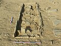
 Central mausoleum (the qubba) of the Column Tomb
 -
 Burial excavation showing the over-pit system and surface arrangements


World Heritage Status[edit]
The archaeological site was added to the UNESCO World Heritage Tentative List on June 14, 2001 in the Cultural category.[36]
References[edit]
- ^ "Koumbi Saleh (Agricultural Urban Commune, Mauritania) - Population Statistics, Charts, Map and Location". www.citypopulation.de. Retrieved 2024-02-16.
- ^ Mauny 1954, p. 201.
- ^ Garrard 1982, p. 450.
- ^ Masonen 2000, p. 516.
- ^ a b Mauny 1954, p. 205.
- ^ Levtzion & Hopkins 2000, p. 7.
- ^ Levtzion & Hopkins 2000, pp. 79–80. A translation into French is available online: El-Bekri 1913, p. 328.
- ^ Houdas & Delafosse 1913, pp. 75-76.
- ^ Hunwick 2003, p. 13.
- ^ Hunwick 2003, p. 13 note 1.
- ^ Gomez 2018, p. 33.
- ^ Masonen 2000, p. 523.
- ^ Insoll 1999, p. 84.
- ^ Mauny 1954, p. 207.
- ^ Levtzion & Hopkins 2000, pp. 109, 390 note 8.
- ^ Masonen 2000, p. 355.
- ^ Levtzion 1973, pp. 46–47.
- ^ Houdas & Delafosse 1913, p. 76 note 2.
- ^ Kritzinger, Ann (November 2010). Close Fit of Seven Towns in Ptolemy’s Geographica with Seven Aoukar Heritage Sites: Impacts on Early Arab Itineraries across Mauritania, Senegal, and Mali. Proceedings of 13th Pan African Archaeological Congress. Dakar, Senegal.
- ^ Bonnel de Mézière 1914.
- ^ Thomassey & Mauny 1951.
- ^ Thomassey & Mauny 1956.
- ^ Berthier 1997.
- ^ Thomassey & Mauny 1951, p. 439.
- ^ Thomassey & Mauny 1951, pp. 440 note 4, 449.
- ^ Thomassey & Mauny 1951, p. 447.
- ^ Thomassey & Mauny 1951, p. 449 note 1.
- ^ a b Mauny 1961, p. 482.
- ^ Mauny 1961, pp. 472–473.
- ^ Mauny 1961, p. 481.
- ^ Berthier 1997, p. 21.
- ^ Levtzion 1973, pp. 23–24.
- ^ Berthier, Recherches archéologiques sur la capitale de l'empire de Ghana (1997): 2.
- ^ Thomassey & Mauny " Campagne de fouilles à Koumbi Saleh " (1951): 436-462; Thomassey & Mauny " Cam¬pagne de fouilles à Koumbi Saleh " (1956): 117-140.
- ^ Devisse & Diallo, " Le seuil du Wagadu " (1993): 108-113.
- ^ Site archéologique de Kumbi Saleh (in French), UNESCO – World Heritage Convention, 14 June 2001, retrieved 8 October 2011.
Bibliography[edit]
- Berthier, Sophie (1997), Recherches archéologiques sur la capitale de l'empire de Ghana: Etude d'un secteur, d'habitat à Koumbi Saleh, Mauritanie: Campagnes II-III-IV-V (1975–1976)-(1980–1981), British Archaeological Reports 680, Cambridge Monographs in African Archaeology 41 (in French), Oxford: Archaeopress, ISBN 0-86054-868-6.
- Bonnel de Mézière, Albert (1914), "Note sur ses récentes découvertes, d'après un télégramme adressé par lui, le 23 mars 1914, à M. le gouverneur Clozel", Comptes rendus des séances de l'Académie des Inscriptions et Belles-Lettres (in French), 58 (3): 253–257, doi:10.3406/crai.1914.73397.
- El-Bekri (1913) [1859], Description de l'Afrique septentrionale (in French), Mac Guckin de Slane, trans. and ed., Algers: A. Jourdan.
- Garrard, Timothy F. (1982), "Myth and metrology: the early trans-Saharan gold trade", Journal of African History, 23 (4): 443–461, doi:10.1017/s0021853700021290, JSTOR 182035, S2CID 162275317.
- Gomez, Michael (2018). African dominion : a new history of empire in early and medieval West Africa. Princeton, NJ: Princeton University Press. ISBN 978-0-691-17742-7.
- Houdas, Octave; Delafosse, Maurice, eds. (1913), Tarikh el-fettach par Mahmoūd Kāti et l'un de ses petit fils (2 Vols.), Paris: Ernest Leroux. Volume 1 is the Arabic text, Volume 2 is a translation into French. Reprinted by Maisonneuve in 1964 and 1981. The French text is also available from Aluka but requires a subscription.
- Hunwick, John O. (2003), Timbuktu and the Songhay Empire: Al-Sadi's Tarikh al-Sudan down to 1613 and other contemporary documents, Leiden: Brill, ISBN 90-04-12560-4. First published in 1999 as ISBN 90-04-11207-3.
- Insoll, Timothy (1999), "Review of: Recherches Archéologiques sur la Capitale de l'Empire de Ghana by Sophie Berthier", African Archaeological Review, 16 (1): 83–85, doi:10.1023/A:1021666919678, JSTOR 25115527, S2CID 160307823.
- Levtzion, Nehemia (1973), Ancient Ghana and Mali, London: Methuen, ISBN 0-8419-0431-6. Reprinted by Holmes & Meier in 1980.
- Levtzion, Nehemia; Hopkins, John F.P., eds. (2000), Corpus of Early Arabic Sources for West Africa, New York, NY: Marcus Weiner Press, ISBN 1-55876-241-8. First published in 1981.
- Masonen, Pekka (2000), The Negroland revisited: Discovery and invention of the Sudanese middle ages, Helsinki: Finnish Academy of Science and Letters, ISBN 951-41-0886-8.
- Mauny, R.A. (1954), "The question of Ghana", Journal of the International African Institute, 24 (3): 200–213, doi:10.2307/1156424, JSTOR 1156424, S2CID 143619637.
- Mauny, Raymond (1961), Tableau géographique de l'ouest africain au moyen age, d'après les sources écrites, la tradition et l'archéologie (in French), Dakar: Institut français d'Afrique Noire. Includes a detailed plan of the archaeological site as Figure 95 on page 480.
- Thomassey, Paul; Mauny, Raymond (1951), "Campagne de fouilles à Koumbi Saleh", Bulletin de l'Institut Français de l'Afrique Noire (B) (in French), 13: 438–462, archived from the original on 2011-07-26.
- Thomassey, Paul; Mauny, Raymond (1956), "Campagne de fouilles de 1950 à Koumbi Saleh (Ghana?)", Bulletin de l'Institut Français de l'Afrique Noire (B) (in French), 18: 117–140.
Further reading[edit]
- Burkhalter, Sheryl L. (1992), "Listening for Silences in Almoravid History: another reading of 'The Conquest That Never Was'", History in Africa, 19: 103–131, doi:10.2307/3171996, JSTOR 3171996, S2CID 163154435.
- van Doosselaere, Barbara (2014), Le Roi et le Potier: Étude technologique de l'assemblage céramique de Koumbi Saleh, Mauritanie (5e/6e - 17e siècles AD), Reports in African Archaeology 5 (in French), Frankfurt am Main: Africa Magna Verlag, ISBN 978-3-937248-43-1.
- Conrad, David C.; Fisher, Humphrey J. (1982), "The conquest that never was: Ghana and the Almoravids, 1076. I. The external Arabic sources", History in Africa, 9: 21–59, doi:10.2307/3171598, JSTOR 3171598, S2CID 163009319.
- Conrad, David C.; Fisher, Humphrey J. (1983), "The conquest that never was: Ghana and the Almoravids, 1076. II. The local oral sources", History in Africa, 10: 53–78, doi:10.2307/3171690, JSTOR 3171690, S2CID 162867483.
- Delafosse, Maurice (1916), "La question de Ghana et la Mission Bonnel de Mézières", Annuaire et Mémoires du Comité d'Études historiques et scientifique de l'AOF: 40–61.
- Masonen, Pekka; Fisher, Humphrey J. (1966), "Not quite Venus from the waves: The Almoravid conquest of Ghana in the modern historiography of Western Africa" (PDF), History in Africa, 23: 197–232, doi:10.2307/3171941, JSTOR 3171941, S2CID 162477947, archived from the original (PDF) on 2011-09-07, retrieved 2009-02-19.
- Fisher, Humphrey J. (1982), "Early Arabic sources and the Almoravid conquest of Ghana", Journal of African History, 23 (4): 549–560, doi:10.1017/s0021853700021356, JSTOR 182041, S2CID 162809860.
- Robert, D.; Robert, S. (1972), "Douze années de recherches archéologique en république islamique de Mauritanie", Annales de la faculté de lettres et sciences humaines (Université de Dakar) (in French), 2: 195–214.
External links[edit]
- Map showing Koumbi Saleh: Fond Typographique Sheet ND-29-XXIII 1:200,000 Nara, République Islamique de Mauritanie, archived from the original on 2012-04-26.