
Oudelande
Oudelande | |
|---|---|
Village | |
 Village square | |
 Coat of arms | |
 Oudelande Location in the province of Zeeland in the Netherlands  Oudelande Oudelande (Netherlands) | |
| Coordinates: 51°24′30″N 3°51′13″E / 51.40833°N 3.85361°E | |
| Country | Netherlands |
| Province | Zeeland |
| Municipality | Borsele |
| Area | |
| • Total | 8.76 km2 (3.38 sq mi) |
| Elevation | 1.0 m (3.3 ft) |
| Population (2021)[1] | |
| • Total | 685 |
| • Density | 78/km2 (200/sq mi) |
| Time zone | UTC+1 (CET) |
| • Summer (DST) | UTC+2 (CEST) |
| Postal code | 4436[1] |
| Dialing code | 0113 |
Oudelande is a village in the Dutch province of Zeeland. It is a part of the municipality of Borsele, and lies about 19 km southeast of Middelburg.
History[edit]
The village was first mentioned in 1312 as "in Badickendorpe ende in Oudelant aen die zuudtzyde", and means "old land", because it was not flooded in 1014.[3] Oudelande is a church village which developed on a ridge which was elevated to a terp (artificial living hill) in the 13th century. The circular structure was not completed on the northern side.[4]
The Dutch Reformed church was originally dedicated to Saint Eligius. The large tower dates from the 14th century. In 1769, a part of the church was demolished and rebuilt.[4]
Oudelande was home to 547 people in 1840.[5] In 1927, a railway station was built on the Goes to Hoedekenskerke railway line. The station closed down in 1934.[6]
The village was severely damaged during the North Sea flood of 1953.[4] Oudelande was a separate municipality until 1970, when it was merged with Borsele.[7]
After running a test for one year, the city council decided to remove all traffic signs in the beginning of 2007 to improve the look of the historical village.[8]
Gallery[edit]
-
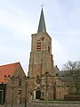 Saint Eligius church in Oudelande
 -
 Former railway station
 -
 Farm in Oudelande


References[edit]
- ^ a b c "Kerncijfers wijken en buurten 2021". Central Bureau of Statistics. Retrieved 19 April 2022.
- ^ "Postcodetool for 4436AA". Actueel Hoogtebestand Nederland (in Dutch). Het Waterschapshuis. Retrieved 19 April 2022.
- ^ "Oudelande - (geografische naam)". Etymologiebank (in Dutch). Retrieved 19 April 2022.
- ^ a b c Piet van Cruyningen & Ronald Stenvert (2003). Oudelande (in Dutch). Zwolle: Waanders. ISBN 90 400 8830 6. Retrieved 19 April 2022.
- ^ "Oudelande". Plaatsengids (in Dutch). Retrieved 19 April 2022.
- ^ "station Oudelande". Stationsweb (in Dutch). Retrieved 19 April 2022.
- ^ Ad van der Meer and Onno Boonstra, Repertorium van Nederlandse gemeenten, KNAW, 2011.
- ^ "Geen verkeersborden meer in Oudelande". Metro (in Dutch). 2007-03-07. p. 19.